ST. PETERSBURG — Linda
Hetterich was in bed when she heard the tornado warning
screech from her husband’s cell phone.
|
Ray Hetterich, 77, was
wrenched awake just as he nodded off while watching TV in
the Florida Room of the couple’s waterfront condo in Boca
Ciega Point, a 55-and-up boating community along the
Intracoastal Waterway.
It was 1:07 a.m. Sunday. The warning covered all of Pinellas
County. About two minutes later, the National Weather
Service reported, a tornado spun from the intracoastal up
the Hetterichs’ street on one of the fingers of land forming
the dredge-and-fill community.
Storms would cause significant damage in the Bay Pines area
and Redington Beach, damaging roofs on condos and
apartments, downing large trees, ripping two light poles
from the ground and knocking boats off their lifts,
according to the Weather Service and Seminole Fire Rescue.
There were no reports of injuries or flooding.
“I’ve never seen anything like it,” Linda Hetterich, 74,
said Sunday afternoon. “Ray got on his laptop to find out
where it was and then we heard a loud bang. It sounded like
a plane crashed into our house.”
It was the sound of the twister peeling
away the couple’s aluminum roof and tossing it on top of the
neighbor’s house before moving on to the next home. |
|
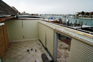
Ray Hetterich of St. Petersburg lost the roof to his
Florida room when a tornado spun up his street near the Intracoastal
Waterway early Sunday. Hetterich had been nodding off in the room
when a tornado warning sounded on his cell phone.
|
The tornado is believed to have
dissipated nearly as quickly as it formed, said Daniel Noah,
a meteorologist with the Weather Service who led its on-site
investigation.
Still, with twisted garage doors and aluminum siding
stretching for 1.3 miles northeast, Noah estimated the
tornado grew to roughly 30 yards with winds around 75 mph.
|
As she helped her
husband board up broken windows and find a missing air
conditioner Sunday, Linda Hetterich said she would have
chosen a different way to spend Valentine’s Day. Still, no
one was hurt. Nothing irreplaceable was lost. The house was
battered and waterlogged, but still standing.
More storms were expected to move in from the Gulf of Mexico
on Sunday, maybe even another tornado, said Bay News 9
meteorologist Nick Merianos.
“There is no distinct time for these storms,” Merianos said.
“They will be on and off throughout the day.”
A south-to-southwest flow over the Florida peninsula was
expected to create strong winds and a deep layer of moisture
over the next 48 hours across the Tampa Bay region. Wind
gusts of 20 to 30 mph were expected with higher gusts along
the coast.
Once the storm system passes, forecasters predicted things
will heat up fast across much of central Florida, with
temperatures in the upper 80s through Thursday, excluding a
cooler day on Tuesday, according to Bay News 9. Another
round of showers and thunderstorms could hit the region
Wednesday and Thursday, forecasters said. |
|
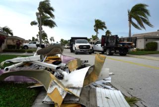
Winds are blowing again as residents and construction
crews clean up after a tornado that spun through the Boca Ciega
Point condominiums early Sunday.
|
While much of the country is seeing
record cold weather, Florida is seeing higher low
temperatures for February than ever before. The low in Fort
Myers on Saturday was 71, breaking the previous record high
minimum for the month of 70 degrees, set in 1920, according
to the Weather Service. Other parts of south and central
Florida could set similar records last week.